Meteorology Professor Joe Schneider gives his predictions for the remainder of winter
BY: RYAN WINZEN
News Editor
The St. Louis area was one of the sections of the United States that was met with severe winter storms during the month of January. The storms, which largely took place during the week of January 5, resulted in the closure of all STLCC campuses for the majority of that week, and had lasting effects on travel in different parts of the city and county over the following weeks.
Physical Science Professor Joe Schneider, a Meramec professor for 25 years, said the factors that go into predicting harsh weather in the St. Louis area has many. He’s predicting a warmer next few weeks, saying “We’ll go back to a little bit above average, around 40s or low 50s.”
He talked more about patterns that determine the severity of the weather.
“Specifically in the winter season, three of our main guides are: is it going to be a normal or neutral winter, is it going to be affected by La Nina or is it going to be affected by El Nino,” said Schneider.
In his 2024-2025 winter weather forecast, Schneider describes El Nino as, “A climate pattern which occurs when the sea surface temperatures are above normal for a long period of time in the equatorial pacific region,” a La Nina as, “A climate pattern which causes water temperatures in the eastern pacific to be below average,” and a neutral winter as, “a climate pattern in which sea surface temperatures across the central and eastern pacific ocean are near average.”
Schneider explained the different sub categories that exist within these guides.
“If it is a La Nina winter, which this one is, will it be weak? Is it going to be weak to moderate? Moderate? Moderate to strong? That actually produces different weather effects and different weather conditions on an everyday basis as far as cold and storms.”
He then explained what type of La Nina our current winter fits under.
“Right now, we are under a very weak La Nina. What is happening right now is pretty close to perfect of what we had realized what a weak La Nina will do. A weak La Nina gives a very consistent cold to most of the eastern two-thirds of the country.”
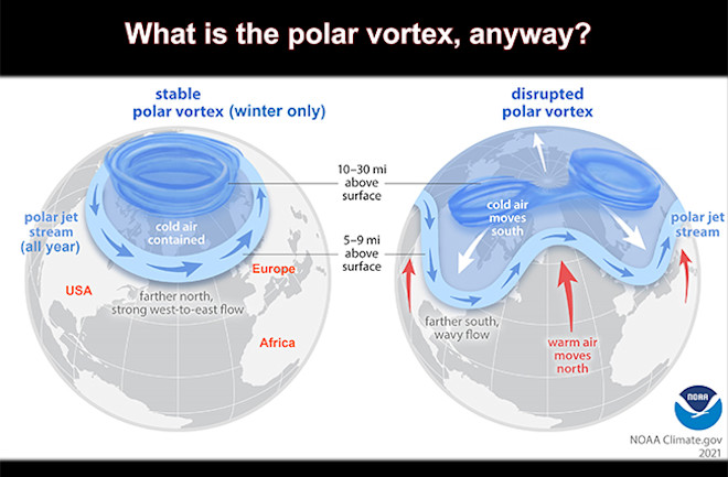
Another factor that determines the winter weather is arctic oscillation.
Schneider describes the AO as, “winds moving counterclockwise across the northern hemisphere. This large-scale counterclockwise circulation is known as the Polar Vortex.”
He explained what occurs when the polar vortex is strong or weak.
“If the polar vortex stays strong, the cold air will move around up to our north, the arctic region, and will never usually come down. We are getting the cold because it is weaker and that allows pieces of it to break off and come down or, what we’ve had this year, is a stretch. A stretch of the polar vortex usually allows the cold to stay around longer.”
Schneider also gave his thoughts for what the rest of the winter will look like.
“We’re going to take a break when we get into the latter part of January and early part of February. I think we’re going to switch. We’re going to get colder air in the western part of the US, and warmer air in the eastern part of the us. We’ll go back to a little bit above average around 40 or low 50. I don’t think that’s going to stay for the rest of the winter.”
He mentioned that the recent storm was a rare phenomenon.
“I hope all you young people witnessed that, and saw that, and will remember this,” he said. “We have not had a storm like that, with that amount of sleet, since 1991.”